- Office Hours: M-F 8:30 AM - 5:00 PM
Marine Resistivity Surveys are now easier, quicker, and more efficient with our 3rd Generation SuperSting™ Marine System.
When towing a streamer you often only have one shot to collect the data correctly. Missing the mark means having to loop around to recollect data—wasting precious survey time. And with no landmarks on the open water, it can be easy to lose track of where you surveyed—even with a GPS.
Our Marine System has solved these problems and more. You can plan your survey beforehand with the AGI Survey Planner, receive real-time Guided Navigation queues, inspect the data with real-time data plots while on the water—and even playback your survey before returning to dry land! That's just the beginning of the Marine System’s capabilities.
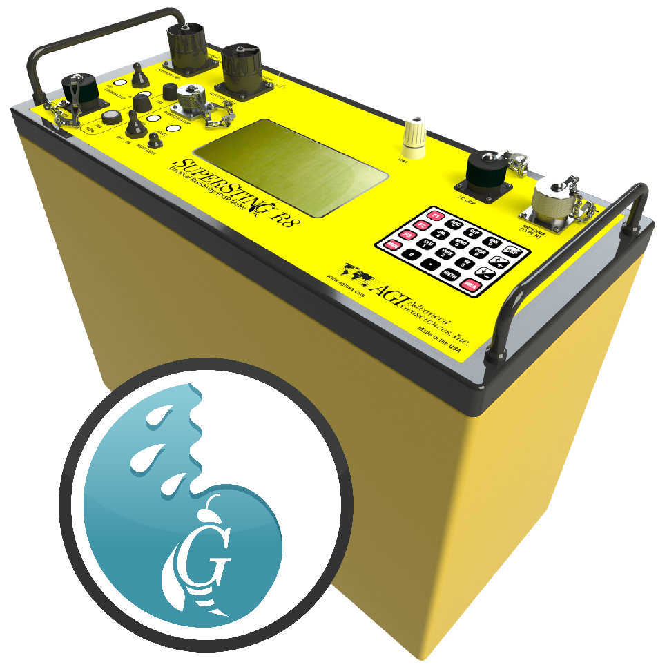
The SuperSting™ Marine Resistivity is an add-on module to the SuperSting™ Wi-Fi—our multi-channel electrical imaging system.
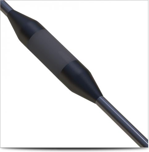
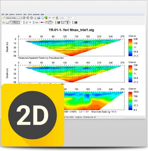
Simply connect the accessories and then tow the sensor cable behind your boat at ~3-8 km/h or 2-5 knots. The module gathers continuous 2D or 2.5D images. In an eight-hour day, it is possible to gather over 40 linear kilometers of data!
This data can be used for myriad reasons, including:
Determining sub-bottom geology for dredging purposes
Monitoring leakage in a dam
Mapping fresh and saltwater interfaces near shorelines or offshore
Characterizing the sub-bottom of estuaries
Measuring water column salinity variations
Mineral exploration (usually placer deposits)
Locating freshwater springs at sea (submarine groundwater discharge)
Distinguishing between hard rock, sand, gravel, silt, and clay
Locating geohazards for marine structures
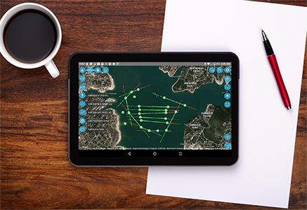
Plan your survey points, time to completion, and costs—all within the app. Sophisticated surveys can be planned and tested rapidly—even while still in the office.
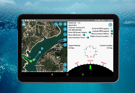
The SuperSting™ Marine System’s App has guided navigation that’s custom-built to deal with the positioning variables that come from being on a boat.
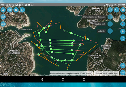
The AGI Route Optimizer Module uses a heuristic algorithm to reduce the n-factorial route optimization problem to a manageable solution. This allows you to minimize your travel distance to save time, save money, collect more data, and easily deal with unexpected route changes.
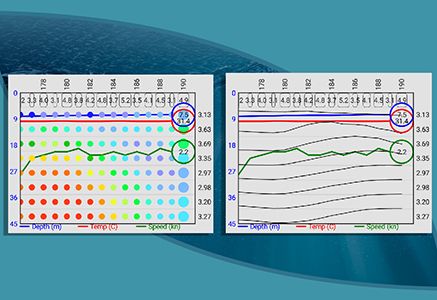
Our Marine System allows you to see data plots in real-time, so you can see if any areas need to be revisited. Data is visualized clearly on the included tablet using a dual-screen map.
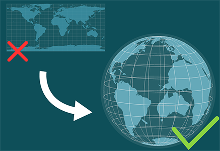
For professional Geophysical data collection, the standard UTM conformal projection can give you errors up to several meters as you travel from one UTM grid zone to another. Our map projections apply geodesic corrections to remove this inaccuracy!

The Playback Mode allows you to replay and review every aspect of your completed survey. Check your data before returning to land or use it to show clients and colleagues.
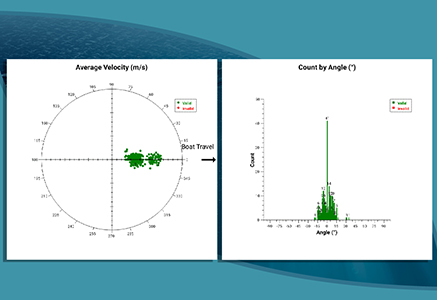
Our GPS Quality Assurance Statistics tool will visually show you how well your GPS performed. Regardless of your GPS device, our reader will make sure that depth, temperature, and GPS positioning are all set up correctly. Using a sophisticated prediction algorithm, the system creates a Polar Plot and Histogram Plot for you to review.
All of the freedom of movement that you enjoy with the SuperSting™ is carried over into the SuperSting™ Marine Module. Using the included tablet and Android App (available in the Google Play Store), you can control and monitor the SuperSting™ from up to 100 meters away.
This product is qualified for 100% financing. Learn more.


When you can see what you're working with below the surface, you can make better decisions that save you time and money.