- Office Hours: M-F 8:30 AM - 5:00 PM
Seawater desalination plants require a large supply of clean seawater to run without causing ecological problems. Common problems include:
Sea animals like fish, shrimp, etc., which get stuck in the inlet screen of the intake by the force of the streaming water.
Other organisms and particles that get through the screen and damage to the desalination process.
Navigational problems can occur when using above seabed water intakes.
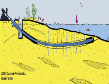
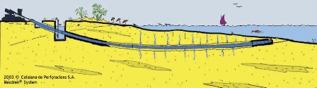
Our customer, Catalana de Perforacions, located in Barcelona, Spain, developed a system called Neodren, which eliminates these problems. It consists of wells drilled horizontally from the beach into the sea bottom. A special porous tube that allows seawater to enter is installed in the horizontal well. The seabed acts as a first filter, and the second filter is the tube itself, which allows only impurity-free water to pass.
Before drilling can start, it is important to locate the best place for the water intake. In order to do this, the client maps the geological formations in the seabed that may provide the best performance. The seabed has to be porous, homogeneous, and thick enough to filter the seawater and be easily drilled.
In April 2007, Catalana de Perforacions used resistivity imaging and AGI tools to map lateral extension and thickness of lithological units from land to offshore. With this information, the client was able to map the lithology to locate the best place and the depth for the horizontal drilling that would be used for the seawater intake for a desalination plant.
The land-to-offshore imaging was done with underwater cables. The client used eight parallel lines—each line had 42 electrodes spaced 6 meters apart. The client used the SuperSting™ R8 with a SwitchBox and a Dipole-Dipole electrode array. EarthImager™ 3D inversion software processed the data.
Our client successfully mapped the geology of the seaside and was able to use that data to understand where the team could drill horizontally.
Ease of use: It’s easy to mobilize in or on water by floating or sinking a cable with molded-on electrodes. Simply hold the electrode cables still, and move them when the measurements are complete. When you’re surveying seashores, waterways, rivers, estuaries, etc., there’s no need to install electrode stakes because you are making contact to the bottom through the water. This is important and time-saving when you’re surveying waterways.
Speedy data acquisition: This case history highlights the system’s capability: Not only is it advantageous to be able to move the cables quickly, it’s important to be able to gather data quickly. Time is money.
Specially designed tools: These rugged instruments are meant for marine work.
Time- and money-saving: With our underwater exploration techniques you don’t need to send down divers to explore—just pull the cable out and let it sink with a rope. Employees stay safe and businesses avoid the risk and expense of using divers, all while gathering extremely accurate data.
Resistivity imaging is an easy way to explore underwater. It’s an ideal choice for bottom investigation, as well as dam leakage and dredging planning.