- Office Hours: M-F 8:30 AM - 5:00 PM
We here at AGI are big advocates of saving time. Seriously, if time is money—then we’re serious penny pinchers. That said, we’re always looking to pass on time-saving tips to you! Today we’re showing you a couple of quick tips that can save you a couple of minutes on the field. Particularly, these tips are focused on electrode preparation and removal. You may scoff at saving a few minutes, but here in the Texas sun—a few minutes is the difference between a suntan and sunburn!

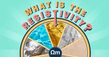
Electrical Resistivity Imaging (ERI) is a fantastic geophysical method for subsurface exploration and delineation (it certainly is our favorite!). In this article, we want to focus more on the “geo” part of geophysics and take a look at some resistivity values for common materials.
You see, ERI works best when you have a good knowledge of the geology of your survey area. In fact, when we’re helping new customers design their survey, or helping someone in the field—the geology of the area is one of our first questions.
...
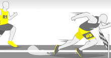
Our customers often want to get the most out of our equipment while sticking to their budget. As such, many will opt for a cheaper single-channel system instead of a multiple-channel system. When customers are weighing the options, we often get the question “What’s the difference between the two?”.
The simple answer? Speed.
Of course, there are a few more bells and whistles that a multi-channel system offers, but the key difference is how much faster it is when compared to a single-channel. That’s what we’ll focus on in this...
In the field, you’ll often find out that Mother Nature isn’t concerned with your project timelines. But whether there’s rain or shine, you’re expected to meet your deadlines. As such, we often get questions from our customers on what kind of weather is reasonable to work in. So in this post, we’ll be listing the weather conditions that pose no problems, conditions that will slow you down, and conditions that will halt your survey completely.
We’ll be discussing how weather affects your survey in general. If you want to learn more about how our...

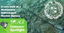
One of the coolest applications of resistivity is in the marine environment. Don’t get us wrong, we love solid earth too (it’s our bread and butter after all)—but when you see footage like the video below, you can’t help but be blown away.
Our friend, Matt Becker from the Conrey Hydrogeology Program at California State University Long Beach recently used our passive graphite electrode cables to do a stationary submerged marine survey. As...
It may be odd that we here at AGI have a favorite sinkhole. But when you’ve been in the business as long as we have, it would be weird if we didn’t have a favorite sinkhole. As the title of this article suggests, we’re taking a quick look back at a sinkhole known as the “Corvette Cave”.
Early one morning in 2014, a 30-foot-deep sinkhole opened up at the National Corvette Museum in Bowling Green, Kentucky. Thankfully, this was during a time when potentially...
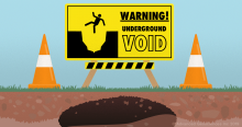
We seem to have formed a bit of a sinkhole blog trilogy. First, we informed you of the 7 Common Signs of Sinkholes. After that, we showed you how you can Test for Sinkholes. Now, in this article, we want to share what to do once you find an air-filled void on your property.
The good news is that you’ve already done most of what you need to do at this point. You’ve already done a geophysical survey—such as an...
We’re finally at the end of this eight-part series. We would like to say “we’ve saved the best suggestions for last”, but all of our suggestions are pretty fantastic reads if you want to learn more about resistivity, induced polarization, and more. Maybe its because we're posting this around the holiday season, or maybe its because we're sad to see the series end, but we've included 4 entries this time around instead of 3.
As we’ve mentioned in previous posts, let us know if you have suggestions for further reading. It doesn’t even have to be about the...

Our eight-part series is nearly concluded. But don’t worry! We still have a few more suggestions for you if you want to learn more about resistivity, induced polarization, and more. In fact, we plan on revisiting this series in the future with newer publications. For now, we’re sticking with the tried-and-true reads that have influenced us over the years. If you have any suggestions on what you think is essential reading, just let us know on social media. We want to keep sharing with our community.
In case you’ve missed it, here are our previous recommendations...

We’re moving right along through this eight-part series! Here is our latest trio of recommendations for further reading. These picks cover experimental design, induced polarization, and the inverse problem theory. You can use these publications as a starting point in expanding your knowledge on these topics. It’s our hope that in checking out these books and papers, it will lead you to find picks that are beyond our list (and if you find something great, let us know on social media)!
For those of you who want to learn more about resistivity, induced...

